Monday 29 March 2021

Saint Patrick was a Cumbrian.


      Saint Patrick, a British Christian Missionary in 5th Century Ireland, born about 387AD, the primary Patron Saint of Ireland, although never formally canonised, though regarded as a Saint.

      There appears to be little evidence about the places he lived and worked, but there is the story he was born possibly in what is now thought to be the Ravenglass area of Cumbria. Captured and taken as a slave to work, looking after Farm Animals for a period of six years. Before a brief return to Cumbria, where he became a cleric and then went back to Ireland again to work in the North and West of the country.

      Ravenglass in the 5th Century was in Viking England as the border with Viking Scotland is just to the north at St Bees.

Sunday 28 February 2021

Last Battle Upon English Soil


       The last battle to be fought in England was in fact at Clifton in Cumbria, although some would try to have this downgraded to nothing more than a skirmish. If this was to be the case then there are quite a number of other British Battles which could be similarly downgraded.

      The battle was fought between the armies of Prince Charles Edward Stewart upon their retreat to Scotland, following the failed conquest of England, and their pursuers the army of the Duke of Cumberland.

      The battle itself isn't well documented but is as important as any other of the Jacobite Rising. The Duke's Army was getting to close to the Prince's retreating forces and a stand was made at Clifton, which resulted in a Highland Charge, which broke the Hanoverian lines and scattered the Duke's troops. Actual losses on either side were no more than a dozen each or less, though wounded numbers are uncertain but the result was a success for the Jacobite Forces as this bought them more time and kept the Hanoverian forces at bay. 

Sunday 31 January 2021

Ambleside Doomsday 1086AD


      In the years after the Norman conquest of England the "new" King, Duke William of Normandy had a large and sprawling kingdom to rule, and with some difficulty collecting taxes and governing a defeated nation largely consisting of to say the least, uncooperative Saxons, from all the existing shires. There was also a wealth of other obligations owed by his subjects to their king which were not always readily and willingly forthcoming. And so in the year 1085 ordered a national survey, to define the present and possible future wealth of his subjects. The property of every person from the King downwards, including Cow, Sheep Ox or Pig.

      The census was completed in 1086 in the form we know as The Doomsday Book but did not include some lands to the North, which remained free of the Norman yoke or was deemed to miserable for inclusion in the book. Quite simply because no Norman had ventured into these wild lands. In time this would change.

      It seems Ambleside falls into the latter descriptions, it's been said Ambleside or even Amels'se'at may at the time have been little more than a couple of enclosures for sheep and several basic homesteads, all of which is uncertain. The modern Cumbria is made up of Cumberland, Westmorland and the Furness part of Lancashire. Westmorland in 1085 consists of the two principle settlements of  Kendal "Cherchebi" (Land of the King) and a collection of lesser settlements. As with Levens "Lefuenes" (Land of Roger de Poitou) and lesser yet familiar settlements.

      With the Lancashire area which became Furness, there is nowhere of any significance and places like Cartmel, Dalton and Ulverston, like many places of this time, still to rise to prominence.

      For Cumberland, the larger county of Cumbria the principle settlements are Millom "Hougenai" (Land of the King) Yet Millom is at the then, very edge of the country, which possessed little of any note other than land. Bootle "Bodele" to the North of Millom is regarded as even less than Millom. The Normans furthest venture into Cumberland. 


Thursday 24 September 2020

A New and Interesting Approach to Time Travel


      Available from Amazonhttps://www.amazon.co.uk/Face-Looks-Familiar-Sure-About-ebook/dp/B01N5Q2SIS/ref=sr_1_33?dchild=1&keywords=kirk+w+smith+books&qid=1600979801&sr=8-33        

Thursday 17 September 2020

Ambleside Roman Fort.


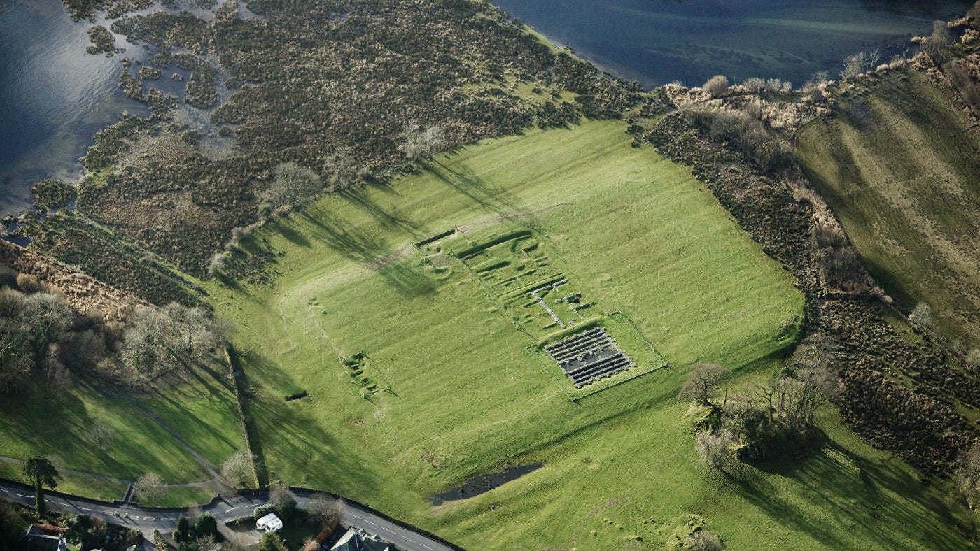
       For many people their first visit to Ambleside Roman Fort can be somewhat disappointing. Their usual comment is; "There's not enough to see!" And in truth there isn't much in actual visible stonework on view and yet a better understanding of the site makes you realise how important the structure really was in those times past.

        Initially, very little was known of the Fort apart from a few mentions in early guide books  and by 1900 was more or less a bare "platform" surrounded by a couple of possible ditches. All this changed through the archaeological excavation led by R G Collingwood between 1913-20. Where they discovered the remains of a fort laid out in a set pattern of Commander's House, Granary, Headquarters and Barracks. The Commander's House, Headquarters and Granary, are the presently exposed remains. The fort was thought to have been constructed about 80AD by the forces of Agricola, whom supposedly passed through this area. The exposed remains are of the second fort built on the site, this and the first having been destroyed in various raids. There have been "digs" in recent years to expose some of the stonework and the East Gate, there are also a number of signboards on site, which give some information about the forts layout.

      Ambleside is an important junction for a number of roads and the lake, then as now and the fort is well placed at the centre of this junction. Currently there are two exposed gates, East and South, but it makes sense there would be a West Gate for access to Hawkshead and Hardknott and a North Gate for access to the Keswick and Kirkstone roads. Next to the fort site there is Borran's Park, Borrans is a Norse word for "piles of stones" or "field of stones" The first thing you notice about Borran's Park is, there are no stones, whatsoever, the site has been swept clean. Probably a good source of building material for the early progress of the modern Ambleside town. Ambleside Roman Town is thought to have stretch from here to as far North as Low Fold and there are some boundary lines still visible in the surrounding land, Ambleside Roman Town has never really been properly investigated and development in recent years as disorientated large parts of the potential town.

      To the North-West of the fort there is a small natural hill, which would be part of any military construction and part of one of the forts, possibly as a observation point or signal station.  

      In the 1950's the level of Windermere Lake was raised, only by inches, but made the small peninsula to the south a lot more moist even boggy. The most southern tip may well have been a likely candidate for a small harbour to receive goods by water transport, there is a known Roman slipway at Lakeside. Still traceable all the way along the east side of this land is the Roman Causeway., still largely intact.

      To the west side of the fort is the river Rothay, navigable as far as the Brathay junction. Also to the west and along side the fort, is a damp often in flood, stretch of ground which gives the impression of one time being a river or similar, but is also thought to have been a canal, Still easily traceable as far North as Rothay Bridge, then afterwards, further to Miller Bridge, beyond this, it's uncertain.

      At the fort there are clear signs of ditches along the north and partially on the west side, which still occasionally flood in damp weather, to the west there is the canal and the south, the lake. Apart from all this, Ambleside, both old and new, over time was a very damp and boggy region and large areas of the town are dominated by stone drains, which criss-cross the landscape. The Roman engineers laid many of these and they exist all over the township and well beyond.       

Sunday 5 July 2020

Viking Influences in Westmorland


      Cumbria is well known for the number of place names and areas associated with Viking or more particularly Nordic settlers and farmers. Less well known is the structure to be found about four miles West of the town of Ambleside, in the Little Langdale Valley. This is a natural hill which has been structured and layered into a recognised platform. This platform takes various names and I've always known it as a "Thing Mot" The interesting point about the Thing Mot, is that there are only two known examples outside Norway, the one above is much more famous at Peel Castle, on the Isle of Man. Whereas the one at Little Langdale is much less known. It's at the end of a valley with limited public access and there is little to be found in the way of ruins, homesteads or antiquarian buildings of any kind. Though at the time it was in use, it must have been very popular, with lots of people living in the near vicinity.
      It's long been supposed Thing Mots were a centre of local Government, or a place of judgement like a modern day court, where disputes may be settled by whatever means. There is the Roman Road to Hardknott and Ravenglass close by as well as the junction to Great Langdale.
      Maybe if you were to score a line from Peel through Little Langdale to Norway, you may well pick up some interesting and historical mystical ruin along the way.

Thursday 28 May 2020

Saint Eanswythe of Folkstone


      Saint Eanswythe, the daughter of an Anglo Saxon King and one of England's earliest Saints is also understood to have founded the first Nunnery in England in 600 AD. She was made a Saint shortly after her death, thought to be in her late teens or early twenties.
      It's only now 1300 years later, a number of bones found in a wall of a Kent church, located close to the original nunnery, have been formally identified. Carbon samples taken from both tooth and bone fragments can now be positively classified as those of Saint Eanswythe.
      The discovery at the church in Folkstone is being hailed as of national importance, as they are thought to be those of not only a saint but also the only surviving bones of a member of the Royal Kentish Household. The remains were found as long ago as 1885. But only now can they be identified with any real certainty.
      Saint Eanswythe, the granddaughter of King Ethelbert, who was the first British King to convert to Christianity under Saint Augustine.